Cape Henlopen
Sunday we drove out to the end of the Cape. You can just barely see the southern most tip of New Jersey, Cape May on the horizon, across the Delaware Bay. While standing atop the north dune view point in the park we watched one of the Cape May Ferries come out of the Bay and head for South New Jersey. There are two lighthouses, one on the bay, and a second at the border between bay and open-ocean. I loved the one-hundred-eighty-degree panorama view of sand dunes, bay, and ocean. After visiting the tip of the cape, Adam drove us South through the state park to the highest point on the beach between Cape Cod and Cape Hatteras. The dunes rise to a height of almost one hundred-eighty-feet, and we had a spectacular view of the beaches below us, the ocean, and an oil tanker coming into the Delaware Bay.
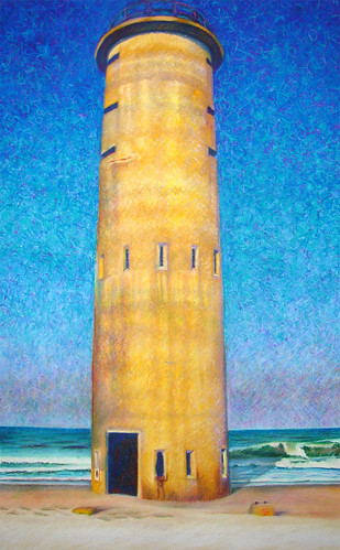
Henlopen State Park was created out of old Fort Miles. There are observation towers throughout the park that were built in order to protect shipping against German U-boats during World War Two. Though they were never actually used for that purpose, they were, however, used to help rescue crews from ships damaged during east coast winter storms. You can even climb one of the towers for a spectacular 360-degree view of the cape, bay, and ocean. Yes, I did climb it, all be it very slowly, and with rests every 10 to 12 steps. All that exercise I have put myself through over the years has paid off. I don’t think too many guys my age could do that climb. I drew a picture of one of the towers at Gordon’s Pond in the Park. I used pastels, and I’ve included it here.
You can send E-mail comments to
ZacSfuts@Comcast.net
, or post them below.
posted by Isaac at 9/21/2006 09:55:00 AM
![]()
![]()


0 Comments:
Post a Comment
<< Home